
In case of an emergency, up-to-date information about the inside of buildings needs to be readily available for first responders. UT researcher Samer Karam developed a wearable mapping system (the ITC-Backpack) that can map building interiors in mere minutes.
Many large public buildings can get quite complex to be accurately mapped. Floor plans (2D maps) represent only important information and can become tangled in complex buildings. They are often difficult to read quickly. To make matters worse, after every reconstruction or renovation process, these maps are outdated. In the case of an emergency, it is important to understand the current situation at a glance. Indoor 3D maps can be the solution.
The spread of COVID-19 raised awareness about the importance of 3D indoor mapping. Digital maps of indoor spaces can help for ensuring social distancing, virtual tourism and real-estate decision making without the need of showing up in person.
3D indoor mapping
Traditional mapping methods depend on static devices, such as terrestrial laser scanners, which take long and can become expensive. They require setting up the device at many different positions Thus, an accurate 3D scan can take hours. For his Ph.D. defense, UT-researcher Samer Karam, developed the ITC-Backpack, a wearable mobile mapping system that can digitize building interiors quickly and at high levels of detail.
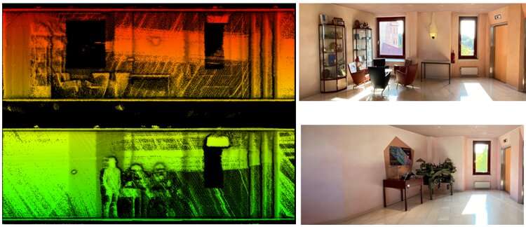
ITC backpack
The system consists of three 2D light detection and ranging (LIDAR) scanners and an inertial measurement unit (IMU). The LIDAR scanners provide laser points. “They record points on the surrounding walls, ceiling and floor,” explains Karam. The IMU measures the accelerations and angular velocities of the backpack over time. This data is used to estimate the pose changes. As global navigation satellite systems (GNSSs) don’t work inside buildings, the ITC-backpack employs a simultaneous localization and mapping (SLAM) algorithm developed during the research trajectory of Karam. “It is LIDAR-IMU-based SLAM that relies on planar structures in the indoor built environments,” he explains.
Loop closure
Creating a 3D map from these 2D data points proved to be difficult. “The sensor noise, pose estimation errors and the complexity of some buildings result in a drift after a while,” says Karam, “When I walked around the first floor in the ITC building and came back to the starting place, the system duplicated the walls of the corridor with some drift. To solve this I developed a specific loop closure technique that makes the backpack system recognize the previously visited places and corrects the drift.”
Testing the system
The backpack was tested in several public indoor environments with various levels of complexity. Karam tested the ITC-Backpack in the Institute of Geodesy and Photogrammetry building at the University of Braunschweig in Germany, the Fire Brigade building in Haaksbergen and several buildings at the University of Twente in the Netherlands. “I even validated the system on the hall that hosted my Ph.D. defense,” says Karam.
Creating 3-D maps of complex buildings for disaster management
Citation:
Creating 3D indoor maps with a wearable backpack system (2021, November 24)
retrieved 24 November 2021
from https://techxplore.com/news/2021-11-3d-indoor-wearable-backpack.html
This document is subject to copyright. Apart from any fair dealing for the purpose of private study or research, no
part may be reproduced without the written permission. The content is provided for information purposes only.
Stay connected with us on social media platform for instant update click here to join our Twitter, & Facebook
We are now on Telegram. Click here to join our channel (@TechiUpdate) and stay updated with the latest Technology headlines.
For all the latest Technology News Click Here
For the latest news and updates, follow us on Google News.
Denial of responsibility! NewsAzi is an automatic aggregator around the global media. All the content are available free on Internet. We have just arranged it in one platform for educational purpose only. In each content, the hyperlink to the primary source is specified. All trademarks belong to their rightful owners, all materials to their authors. If you are the owner of the content and do not want us to publish your materials on our website, please contact us by email – [email protected]. The content will be deleted within 24 hours.